
CDP – Housing Support Service
Intending to assist 3000 families (15000 individuals) in Paravur Taluk, through value added, appropriate and affordable Housing solutions, Habitat for Humanity India with the support of Center for Disaster philanthropy has implemented Housing Support Services in the area. The Housing Support Services in Kerala is in the reconstruction phase of Kerala Floods Disaster response of HFH India to assist families to repair, retrofit or reconstruct a safe and durable house.
The Housing Support Services plays a key role in empowering the families/communities to get Technical services, financial education, and optimum utilization of the funds available. HFH India Housing Support Services are a value added service to the families and the technical people (Masons) on land use planning, site selection, hazard specific disaster resilient house design and plan development, estimation, advising on cost effective durable materials, cultural practices, ensuring local building codes and specifications are followed in the construction work. The HSS hub will conduct on – site training for the Technical people and Construction Planning, Supervision and Management training to the family members. The HFH India HSS center will develop IEC disaster resilient safe construction techniques, House repairs and House maintenance as part of disaster risk mitigation. HFH will develop mobile based technical assistance program for families to obtain information instantly.
As part of 2018 post-floods, Rebuilding Kerala efforts, Habitat India launched a pilot Housing Support Service (HSS) initiative in North Paravur Municipality. HSS was designed here as a Hub and Spoke model with a Core Team of 2 persons functioning out of the Municipal Office (Hub) and also supporting a nearby Panchayat (Spoke). At HFH India, we define Housing Support Services, or HSS, as ‘A demand-driven’ service or product designed to enable a household to:
- Reach an adequate housing quality standard in secure tenure, basic services, and shelter durability and space.
- Make shelter-related improvements in health, safety and livelihood.
HSS has become a significant “scaling” strategy, serving more families than engaging in direct construction. It provided us with an opportunity to
reach out to more low income families by collectively engaging with multiple stakeholders such as government institutions, housing service companies
(MFIs, Banks and NBFCs), Local NGO partners / CBOs and beneficiaries. HSS creates awareness, provides knowledge and access to resources thereby
improving the standard of living of the beneficiary communities. This complements our core competencies in housing and sanitation. HFH India’s
approach to HSS uses housing value chain analysis to identify gaps in the informal incremental housing process.
Kerala was recently deluged with devastating floods affecting over a million households. As part of Rebuilding Kerala, as also encompassing
existing schemes of the Government India (PMAY) and Government of Kerala for affordable housing (LIFE Mission), the Ernakulam District has
launched an initiative to provide houses to the low income families across the district.
| Total No. of Families Served = 172 | ||
|---|---|---|
| Sl.no. | Activities | No of families impacted |
| 1. | Structural plan and approval procedures | 95 |
| 2. | Monitoring visits, quality checking | 153 |
| 3. | Support for availing financial support | 146 |
| 4. | Technical and documentation assistance | 172 |
| Table 2: The number of families impacted through HSS in North Paravur | ||
Paravur Taluk
Known as one of the architectural splendours of Kerala, Paravur is a taluk of Ernakulam district in the Indian State of Kerala. At an elevation of 13 meters, with an area of 195.25 Km* and coordinates at 10.1446° N, 76.2273°E, Paravur Taluk lies in the north western part of the Ernakulam district bordering Thrissur district. The surrounding Taluks are Kochi to the west, Kodungallur to the north, Chalakudy to the north, Aluva to the east, and Kanayannur to the south. Being a part of Kochi urban agglomeration area, the western parts of Taluk are coastal areas with cultivations like prawn and pokkali rice whereas the eastern parts are fertile lands. Kunjithai is one of the most famous fishing boat manufacturing places in Kerala with 30 Boat yards. Until a decade back, Paravur was small countryside hamlet famous for its unique variety of rice known as pokkali, coir, handlooms, agriculture as well as extensive backwater fishing, however now it is changing to a major residential suburb of Cochin. The Paravur Taluk lies in the flat delta region of the Periyar River and cut by several canals, which have resulted in the formation of many islands.
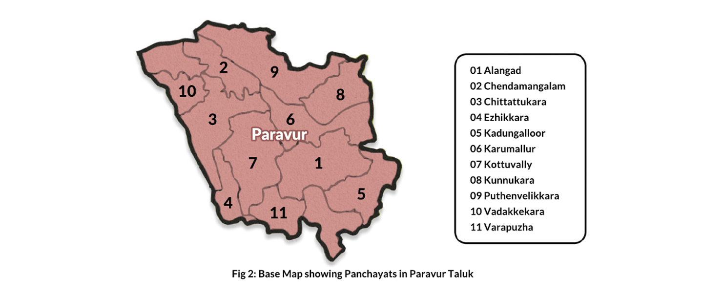
The Taluk consists of 11 Panchayats such as Vadakkekara, Chendamangalam, Chittattukara, Kottuvally, Ezhikkara, Puthenvelikara, Kunnukara, Karumallur, Kadungallur, Alangad, Varapuzha and two municipalities such as Eloor and Paravur. Taluk was an attraction to Kochi, Malabar and Travancore Kingdoms and the capital of Paravur Taluk, North Paravur (formerly known as Paravur) is an emerging suburb of Kochi City which is nearly 22 km from the city centre and 16 km from city, in Ernakulam. The city and its adjoining villages are famous for its legacy in ancient Chera Empire, being the erstwhile capital city of so. The town rose to fame, with first major excavations carried out, that threw light into lost port city of Muziris, hailed as largest port of ancient world.
Heritage sites in North Paravur is an outstanding example of building and archaeological sites and landscape which illustrates a significant stage in the human history of Kerala. The synagogue at Chendamangalam reflects traditional Kerala architecture and has utilized western construction technology and shows us the times and lives of the Jews whereas Paliyam Palace, was once the abode of the Paliath Achans.
The topo-lithosequences of Kerala along with variation in rainfall, temperature and alternate wet and dry conditions particularly from the western coast to high ranges in the east and swift flowing rivers lead to the development of different types of natural vegetation and soil. North Paravur Taluk falls under the category of coastal plains where the general elevation of coast is less than 8.0 m above mean sea level (AMSL). Paravur Taluk of Ernakulam district has a total population of 4,10,571 as per the Census 2011, out of which 2,00,612 are males while 2,09,959 are females. In 2011 there were total 1,02,472 families residing in Paravur Taluk.
The Average Sex Ratio of Paravur Taluk is 1,047. The population of Children of age 0-6 years in the Taluk is 37,799 which is 99a of the total population. There are 19,283 male children and 18516 female children between the ages 0-6 years. Thus as per the Census 2011 the Child Sex Ratio of the Taluk is 960.The total literacy rate of Paravur Taluk is 95.8896. The male literacy rate is 88.0296 and the female literacy rate is 86.1396.The Taluk consists of 11 Panchayats — Vadakkekara, Chendamangalam, Chittattukara, Kottuvally, Ezhikkara, Puthenvelikara, Kunnukara, Karumallur, Kadungalloor, Alangad, Varapuzha and two municipalities – Eloor and Paravur.
| Sl.no. | Panchayat Name | Block | Area of the Panchayat(Sq.Km) | No. of Words | Population | Population Density (Sq.Km) | Population | Sex Ratio | ||||
|---|---|---|---|---|---|---|---|---|---|---|---|---|
| Male | Female | Total | Male | Female | Total | |||||||
| 1. | Alangad | Alangad | 18.35 | 21 | 15873 | 15997 | 31870 | 1739 | 94.97 | 87.96 | 91.55 | 1008 |
| 2. | Cheodzmaogalnm | Paravur | 10.72 | 18 | 14153 | 15173 | 29326 | 2477 | 97.96 | 93.52 | 95.63 | 1079 |
| 3. | Chittatttikar4 | Paravur | 09.46 | 18 | 17562 | 18671 | 36233 | 2677 | 95.59 | 89.39 | 92.37 | 1068 |
| 4. | Ezhikkkara | Paravur | 15.27 | 14 | 8784 | 9235 | 18019 | 1126 | 96.41 | 88.47 | 92.34 | 1036 |
| 5. | Kndungalloor | Alangad | 18.06 | 21 | 21505 | 21612 | 45117 | 1691 | 95.00 | 93.00 | 94.00 | 994 |
| 6. | Knrurnallur | Alangnd | 21.50 | 20 | 21076 | 21852 | 42928 | 1398 | 93.17 | 85.13 | 89.15 | 999 |
| 7. | Kottiivally | Paravur | 20.82 | 22 | 21034 | 21888 | 42922 | 1658 | 95.86 | 89.27 | 92.46 | 1052 |
| 8. | Kunnukam | Parakkadavu | 21.25 | 15 | 10610 | 11155 | 21765 | 929 | 93.17 | 86.69 | 89.85 | 1045 |
| 9. | Puthenvclikara | Parakkadaxu | 19.87 | 17 | 16251 | 17121 | 33372 | 1522 | 96.58 | 93.28 | 94.87 | 1049 |
| 10. | vadakkcknra | Paravur | 09.32 | 20 | 15004 | 16262 | 31266 | 2779 | 96.48 | 90.37 | 93.25 | 1084 |
| 11. | Varapuzha | Alangad | 07.74 | 16 | 10993 | 11521 | 22514 | 2909 | 96.38 | 91.50 | 93.88 | 1048 |
| Table 2: Basic data of Panchayats (Source: Actions plans of Panchayats as per the survey conducted in 2018-2019) | ||||||||||||